Conquest of country from Lahore to Attock by Sardar Gujjar Singh Bhangi - took twelve years.
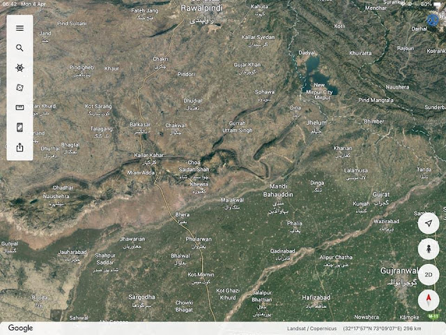
The country between rivers Jhelum and the Indus was full of ravines, and it was an arid area.
Between Rohtas and Rawalpindi, a distance of about 100kms Jherar, Jagatpur, Perwala and Pakoke Sarae were the strongholds of the Gakhars, a hardy and numerous tribe of great valour. Sultan Mukarram Khan of Perwala, Karmullah Khan of Dhani, and Mansur Khan of Gheb submitted to Gujar Singh.
The districts of Dhani and Gheb were famous for a fine breed of horses and mules. It enabled Gujar Singh to equip his army better.
Pothohar also fell to Gujar Singh. It consisted of two parganahs, Wangli and Perwala. Wangli contained eight tappas with its headquarters at Karla Town.
In addition to Gakhars, there were other tribes such as Awans, Dhunds and Gulers. They were widely scattered. But their thickest population was in the districts of Jhelum and Rawalpindi.
In Jhelum district they occupied the tracts of Awan Kari lying across river Gabir. They occupied a strong position in Rawalpindi district. The Awan strongholds in Rawalpindi districts were at Chihan, Jand Bugdial and Sarwala. An Awan clan known as Guleras, notorious for marauding activities, lived to the north of Rawalpindi. The Dhund tribe, a lawless and refractory people, inhabited the hilly region to the north of Rawalpindi between Hazara and Murree. Their citadels were at Dewal, Kahuta and Murree. It was with such people that Gujar Singh had to deal with.
Attock
Between Rawalpindi and Attock there was Margalla Pass. It separated KiWichitta and Khairimurat hills. At Attock there was not a single tree on the plain. It was as level as a sheet of water. The town was situated inside the fort. It lay on the spur of a hill sloping towards the river Indus. Hence its inside was visible from the western bank of the river. The mud fort of Khairabad situated on the other bank of the Indus opposite Attock commanded the full view of the fort of Attock. The western side of the fort was washed by the Indus.
The fort was a triangle in shape, and its other two sides were surrounded by two ravines. Each side of the hill of-Attock was about 3 kms long. There was no well inside the fort. Water was available from the Indus through a passage called Abduzd. The river washed the hills on two sides. The current of water in the Indus at Attock was about 80 metres wide, being the narrowest in the plains, and 20 metres deep. In 1800 the water rose to a depth of 23 metres.
Alushakhsa jagirs
The subjugation of the warlike tribes in the north-western Panjab
was effected by Gujar Singh Bhangi in about twelve years. The Awans, Dalals, Gakhars, Ghebas, Guleras, Janjuas, Jodras, Khatars, Runials and Tarkhelis of the Jehlam and Rawalpind districts and theSalt Range, aLl gave way before him. In this difficult task he wasassisted by Charat Singh Sukarchakia. By 1770 the Gakhars werecompletely subdued.
Source : Dr Hari Ram Gupta’s History of the Sikhs.


Comments
Post a Comment